Category:Maps
From Wikimedia Commons, the free media repository
(an) Mapa · (ar) خريطة · (ast) Mapa · (bg) Карта · (bn) মানচিত্র · (bs) Karta · (ca) Plànol · (cs) Mapa · (cy) Map · (da) Kort (geografi) · (de) Karte (Kartografie) · (eo) Mapo · (es) Mapa · (et) Kaart (kartograafia) · (fa) نقشه (زمین) · (fi) Kartta · (fr) Carte géographique · (gan) 地圖 · (gl) Mapa · (he) מפה · (hi) मानचित्र · (hr) Karta · (hu) Térkép · (id) Peta · (is) Kort · (it) Mappa · (ja) 地図 · (ka) გეოგრაფიული რუკა · (ko) 지도 · (la) Tabula geographica · (lb) Landkaart · (lt) Žemėlapis · (ml) ഭൂപടം · (ms) Peta · (nl) Kaart (cartografie) · (nn) Kart · (no) Kart · (oc) Mapa · (pl) Mapa · (pt) Mapa · (ro) Hartă · (ru) Географическая карта · (sa) Хаарта · (sco) Cairt · (si) ple:Map · (sk) Mapa · (sl) Zemljevid · (sq) Harta · (sr) Карта (мапа) · (su) Atlas · (sv) Karta · (sw) Ramani · (ta) நிலப்படம் · (tg) Харита · (th) แผนที่ · (tl) Mapa · (tr) Harita · (uk) Географічна карта · (vi) Bản đồ · (yi) מאפע · (zh) 地图 · (zh-classical) 地圖 · (zh-yue) 地圖 ·
Before changing or adding maps, please read the brief guideline on the organizational schema About this Category developed during an eight month effort by a working group in 2007-2008.
- See also maps needing categories in Category:Unidentified maps
- See also these related categories: (These categories may contain more maps. Please categorize them in map categories.)
- Category:Cartography - for map symbols, projections, etc.
- Category:Demography
- Category:Geography
- Category:Aerial photographs
- Category:Satellite pictures
- Category:Astronomical maps - maps and star charts
- Category:Cartographic reliefs for models of landscape profiles
Resources:
Subcategories
This category has the following 21 subcategories, out of 21 total.
!
*
?
A
D
E
I
M
N
O
P
S
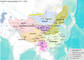
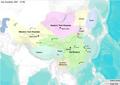
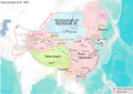
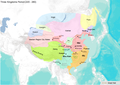
Media in category "Maps"
The following 200 files are in this category, out of 984 total.
(previous page) (next page).jpg/120px-..._map_of_Harishchandragad_(6841471361).jpg) ... map of Harishchandragad (6841471361).jpg 4,000 × 2,672; 4.33 MB
... map of Harishchandragad (6841471361).jpg 4,000 × 2,672; 4.33 MB
 01 - Орографическая карта южной части Среднего Урала, 1904 г.jpg 1,000 × 700; 323 KB
 02 - Карта Полевского района Свердловской области, 1936 г.jpg 1,000 × 700; 265 KB
 03 - Карта Генерального штаба O-40-132-Г-г.jpg 1,000 × 700; 309 KB
 1455 Nautical Chart by Bartolomeo Pareto.jpg 6,065 × 2,982; 5.67 MB
 1600s map of Africa.jpg 3,024 × 4,032; 2.59 MB
 1909 Map of Malabar.jpg 2,560 × 1,920; 587 KB
 1967-01 carte ruffray.jpg 361 × 337; 24 KB
 19th Century Map of Birling, Kent.png 447 × 271; 315 KB
 19th century map of Sundridge with Ide Hill.jpg 424 × 477; 84 KB
 2008specelectsen.png 820 × 630; 22 KB
 2016 07 15 AFC Tiko Kamerun 2.PNG 1,360 × 768; 901 KB
 2016 07 15 Tiko Kamerun AFC.jpg 1,360 × 768; 98 KB
 20th Century map of Friston.png 609 × 379; 572 KB
 20th Century map of Ringshall, Suffolk.png 651 × 326; 411 KB
 8 mataredonda.jpg 3,481 × 2,594; 1.55 MB
 9-0f11e15c1e.jpg 638 × 373; 102 KB
 A 20th Century map of Lower Hardres.png 473 × 683; 724 KB
)_(20049117804).jpg/120px-A_complete_guide_to_the_English_lakes_(186-_))_(20049117804).jpg) A complete guide to the English lakes (186-?)) (20049117804).jpg 2,400 × 1,465; 1.11 MB
A complete guide to the English lakes (186-?)) (20049117804).jpg 2,400 × 1,465; 1.11 MB
)_(20049126214).jpg/120px-A_complete_guide_to_the_English_lakes_(186-_))_(20049126214).jpg) A complete guide to the English lakes (186-?)) (20049126214).jpg 2,400 × 1,471; 1.07 MB
A complete guide to the English lakes (186-?)) (20049126214).jpg 2,400 × 1,471; 1.07 MB
)_(20484934889).jpg/120px-A_complete_guide_to_the_English_lakes_(186-_))_(20484934889).jpg) A complete guide to the English lakes (186-?)) (20484934889).jpg 2,032 × 1,442; 632 KB
A complete guide to the English lakes (186-?)) (20484934889).jpg 2,032 × 1,442; 632 KB
)_(20662458482).jpg/120px-A_complete_guide_to_the_English_lakes_(186-_))_(20662458482).jpg) A complete guide to the English lakes (186-?)) (20662458482).jpg 2,208 × 1,399; 714 KB
A complete guide to the English lakes (186-?)) (20662458482).jpg 2,208 × 1,399; 714 KB
)_(20678406821).jpg/120px-A_complete_guide_to_the_English_lakes_(186-_))_(20678406821).jpg) A complete guide to the English lakes (186-?)) (20678406821).jpg 2,400 × 1,434; 820 KB
A complete guide to the English lakes (186-?)) (20678406821).jpg 2,400 × 1,434; 820 KB
 A map of Echo Lake published 12 March 1947.pdf 5,520 × 3,719; 494 KB
 A Short History of Wales - Section from Holyhead to Cardiff.jpg 2,550 × 1,178; 143 KB
 Aa and connecting waterways.jpg 500 × 556; 167 KB
 Acta Eruditorum - VII mappe arabia mesopotamia, 1692 – BEIC 13352531.jpg 1,653 × 1,901; 239 KB
 Adja-to map.jpg 3,639 × 3,118; 355 KB
 Admin-map-Novosibirsk-region.gif 500 × 375; 22 KB
 Admin-map-Orel-region-small.gif 300 × 266; 16 KB
 Admin-map-Smolensk-region-big.jpg 600 × 593; 103 KB
 Admin-map-Tambov-region.gif 400 × 441; 27 KB
 Admin-map-Tomsk-region.gif 500 × 358; 20 KB
 Admin-St-Vinc.JPG 295 × 530; 11 KB
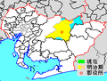 Aichi HigashiKamo-gun.png 210 × 160; 5 KB
 Aichi HigashiKasugai-gun.png 210 × 160; 4 KB
 Aip-vfr-karte.jpg 2,448 × 3,264; 1.24 MB
 Alley First map, Varna, Bulgaria.png 1,254 × 654; 288 KB
.jpg/120px-Alsen-Apenrade-Flensburg_(Geerz).jpg) Alsen-Apenrade-Flensburg (Geerz).jpg 2,996 × 2,029; 1.9 MB
Alsen-Apenrade-Flensburg (Geerz).jpg 2,996 × 2,029; 1.9 MB
 Amcolonies17th-WSC.gif 6,532 × 10,200; 894 KB
.jpg/120px-Amir_Timur%27s_resume_-_cities_he_conquered_(9330886107).jpg) Amir Timur's resume - cities he conquered (9330886107).jpg 3,446 × 2,201; 1.47 MB
Amir Timur's resume - cities he conquered (9330886107).jpg 3,446 × 2,201; 1.47 MB
 An Lushan Rebellion.png 1,275 × 902; 83 KB
 Andaman nicobar 7.jpg 388 × 898; 79 KB
 Antioch Alexandria and Seleucia.png 589 × 349; 516 KB
 Approximate route of Sarah Kemble Knight's Journey, 1704-1705.png 1,100 × 788; 1.65 MB
.jpg/77px-Arbeitslager_Workuta_(Lageskizze).jpg) Arbeitslager Workuta (Lageskizze).jpg 1,662 × 2,568; 900 KB
Arbeitslager Workuta (Lageskizze).jpg 1,662 × 2,568; 900 KB
 Arciechow.map.png 213 × 164; 7 KB
 Arikara Villages, 1823-1886, PNG file.png 1,076 × 863; 1,022 KB
 ARKO.jpg 712 × 696; 120 KB
 Arr neufchateau.jpg 600 × 600; 122 KB
 Aruba-Tourist-Map-.jpg 1,360 × 1,159; 217 KB
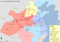
 Asia 400ad-kidarites.jpg 886 × 608; 326 KB
 Asset 1@250x-100.jpg 1,624 × 1,309; 316 KB
 Atavakan lur.png 1,500 × 900; 380 KB
 AtlanticCoastPipeline map.pdf 1,922 × 1,304; 351 KB
 Atlas historyczny RP.jpg 4,109 × 3,330; 19.03 MB
 Aurseulles a.png 2,000 × 1,290; 500 KB
..jpg/96px-Austla_k%c3%bcla_lapimaad_J.Thomsoni_kaart_1928_(1855)..jpg) Austla küla lapimaad J.Thomsoni kaart 1928 (1855)..jpg 1,800 × 2,259; 475 KB
Austla küla lapimaad J.Thomsoni kaart 1928 (1855)..jpg 1,800 × 2,259; 475 KB
 Austronesia Map.jpg 1,350 × 696; 307 KB
 Averdunkshof.png 3,019 × 2,283; 5.3 MB
 Babanpur.jpg 1,248 × 1,824; 264 KB
.png/120px-Babylon%26Seleuicia1(Peutinger_Map).png) Babylon&Seleuicia1(Peutinger Map).png 391 × 142; 141 KB
Babylon&Seleuicia1(Peutinger Map).png 391 × 142; 141 KB
 Bagmara.gif 780 × 606; 75 KB
 Bahm.jpg 640 × 627; 152 KB
 Baja 4000 Map.jpg 781 × 427; 159 KB
 Balkmap.jpg 1,595 × 1,592; 194 KB
 Baltų vandenvardžiai.svg 733 × 590; 89 KB
 BAN DO QH KCN TAN KIM.jpg 707 × 500; 177 KB
 Ban do quy hoach lot K kizuna.jpg 563 × 791; 125 KB
 Banff–Airdrie 2013 Riding.png 2,242 × 4,177; 100 KB
 Banlaky-big hadtortpic 2112b.jpg 1,157 × 825; 376 KB
 Battle of Aboukir 07.25.1799. Map.jpg 809 × 550; 205 KB
 Battle of Boju.png 836 × 552; 704 KB
 Battle of Changping.png 831 × 545; 614 KB
 Battle of Changshao.png 917 × 590; 760 KB
 Battle of Chengpu.png 852 × 540; 679 KB
 Battle of Fei River.png 916 × 586; 428 KB
 Battle of Guiling.png 816 × 551; 410 KB
 Battle of Handan.png 806 × 559; 590 KB
 Battle of Hulao.png 950 × 608; 563 KB
 Battle of Maling.png 811 × 528; 585 KB
 Battle of Xiao.png 870 × 557; 701 KB
 Battle-River–Crowfoot 2013 Riding.png 2,242 × 4,177; 100 KB
 Bears-ears-map.pdf 1,275 × 1,650; 887 KB
 Bebauungsplan der Neu-Stadt Ostra.png 794 × 539; 750 KB
 Beech Fm 1826.jpg 591 × 289; 26 KB
 Bengaluru OpenStreetMap.png 1,157 × 953; 1.63 MB
 Bensonmap.jpg 1,080 × 1,080; 257 KB
 Beratungsstellen der Verbraucherzentrale Thüringen e.V.gif 660 × 540; 19 KB
 Bergendalfarm.jpg 1,323 × 1,047; 337 KB
 Bergrevier Dillenburg.jpg 1,504 × 1,331; 376 KB
 BH sale map1848.jpg 1,056 × 787; 56 KB
 Biomed Area Map.png 221 × 192; 31 KB
 Biomed Area Map2.png 193 × 150; 51 KB
 Birling 19th Century Map.png 473 × 298; 346 KB
 Blankenburger Stadtplan 1891.jpg 5,536 × 4,353; 3.11 MB
 BleeckerSt.jpg 400 × 315; 140 KB
 BloqueioBrDoPrata.png 621 × 275; 196 KB
.jpg) Blueprint map showing holdings of Capilano Timber Co. Limited (14186569274).jpg 1,581 × 2,000; 2.26 MB
Blueprint map showing holdings of Capilano Timber Co. Limited (14186569274).jpg 1,581 × 2,000; 2.26 MB
 Bodleian Libraries, Geographical dominoes.jpg 494 × 361; 36 KB
 Bodleian Libraries, Panorama of A beautiful view of Brightelmstone.jpg 750 × 1,000; 120 KB
 Bogatan kingdom.png 1,024 × 791; 188 KB
 Boston neighborhoods.png 2,625 × 2,325; 1.43 MB
 Boulogne Comte 1150.png 411 × 303; 86 KB
 Bow-River 2013 Riding.png 2,242 × 4,177; 100 KB
 Boyeka.jpg 1,757 × 2,070; 604 KB
 Brabant 1500.png 603 × 550; 889 KB
 Bristol trade routes1492.png 1,735 × 1,761; 330 KB
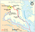 British Advance on Washington, August 1814.png 639 × 584; 112 KB
 British and German offensives in Libya, 1940-1941.png 890 × 689; 95 KB
 British Army Adaptable Force - Overseas Brigade Focuses.svg 863 × 443; 951 KB
 British Possessions in 1842 in and Near Present-day India.jpg 1,051 × 878; 141 KB
 Brixen map.jpg 1,054 × 899; 235 KB
 Brugiroux Parcours.png 3,937 × 2,154; 15.19 MB
 Bryansk-city-baptist-church.jpg 640 × 425; 110 KB
 Bu şəkildə avarların məskunlaşması göstərilir. .png 1,252 × 779; 1.58 MB
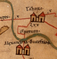 Bucefala and Spartura.png 207 × 215; 116 KB
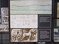 Budapest, Transport Museum 2015, 336.jpg 2,592 × 1,944; 1.25 MB
 Buffeljasriver.jpg 1,769 × 2,836; 1.54 MB
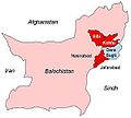 Bugti marri area.jpg 300 × 270; 16 KB
 Business Region Aarhus.png 1,126 × 944; 62 KB
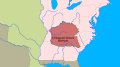
 Buzi locations.png 1,055 × 899; 595 KB
 BV017048106.jpg 6,458 × 6,833; 5.64 MB
 Bílany plán1924 Fr Vykydal.jpg 1,361 × 981; 258 KB
 Caceres - Mapa municipal población.png 2,000 × 1,062; 507 KB
 California Central Railway - Santa Fe 1888 map.jpg 1,500 × 1,972; 512 KB
 California Central Railway map.jpg 1,632 × 2,148; 524 KB
 California Green Trade Corridor.jpg 686 × 345; 61 KB
 Calle Mayor, 25.JPG 989 × 549; 50 KB
 Camaguey2.jpg 297 × 293; 27 KB
 Camp-pico-blanco-california-vicinity-map.png 853 × 900; 198 KB
 CampusKollegietsParkOversigt.jpg 1,498 × 1,424; 930 KB
.jpg/98px-CampusMap2011(0).jpg) CampusMap2011(0).jpg 680 × 829; 520 KB
CampusMap2011(0).jpg 680 × 829; 520 KB
 Canal de Roubaix location.jpg 1,000 × 716; 312 KB
 Canoa-Quebrada-Mapa.png 1,134 × 865; 205 KB
 Carolina Gold Belt.jpg 419 × 654; 105 KB
 Carte de Grand Yoff.jpg 3,507 × 2,480; 1.99 MB
 Carte de l'euroïsation en Europe.svg 710 × 703; 672 KB
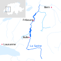 Carte de la Sarine.svg 512 × 512; 25 KB
 Carte du Grand Angoulême.png 5,208 × 5,016; 1.42 MB
 Carte gic.jpg 640 × 237; 28 KB
 Carte JU et JUBE.png 1,313 × 805; 148 KB
 Carte routière.jpg 4,096 × 2,304; 2.91 MB
 Carte-suriname-districts.jpg 2,000 × 2,047; 281 KB
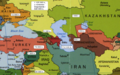
 Caucasus regions map svenska.svg 2,006 × 1,618; 153 KB
 Cavan Towne Map 1591.jpg 1,024 × 768; 158 KB
 Cbe metro.jpg 318 × 387; 88 KB
 CentrosPobladosHuanta.png 452 × 400; 22 KB
 Chalgrove Battle Map.png 1,449 × 1,998; 1.27 MB
.png/120px-Charax_(Peutinger_Map).png) Charax (Peutinger Map).png 297 × 278; 83 KB
Charax (Peutinger Map).png 297 × 278; 83 KB
 Charlestown Area Map.png 120 × 82; 8 KB
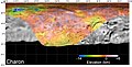 Charon Basemap DEM Grid.jpg 2,130 × 1,074; 1.26 MB
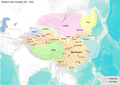 China in Eastern Han dynasty.png 1,275 × 902; 1.17 MB
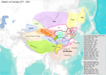 China in Eastern Jin dynasty.png 1,275 × 902; 1.07 MB
 China in Five dynasties.png 1,275 × 902; 1.17 MB
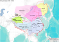 China in Ming dynasty.png 1,275 × 902; 1.18 MB
 China in Northern and Southern dynasties.png 1,275 × 902; 1.16 MB
 China in Northern Song dynasty.png 1,275 × 902; 1.19 MB
 China in Qin dynasty.png 1,275 × 902; 1.21 MB
 China in Qing dynasty.png 1,275 × 902; 1.13 MB
 China in Southern Song dynasty.png 1,275 × 902; 1.18 MB
 China in Sui dynasty.png 1,275 × 902; 1.16 MB
 China in Tang dynasty.png 1,275 × 902; 1.21 MB
 China in Three Kingdoms Period.png 1,275 × 902; 1.18 MB
 China in Western Han dynasty.png 1,275 × 902; 1.19 MB
 China in Western Jin dynasty.png 1,275 × 902; 1.18 MB
 China in Xia and Shang dynasties.png 1,275 × 902; 1.15 MB
 China in Yuan dynasty.png 1,275 × 902; 1.16 MB
 China in Zhou dynasty.png 1,275 × 902; 1.17 MB
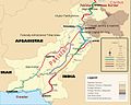 China Pakistan Economic Corridor.jpg 3,000 × 2,395; 1.66 MB
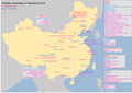 China Universities Map.png 1,275 × 902; 123 KB
 Chorley 2014.jpg 705 × 600; 200 KB
 Chu-Han Contention.png 1,275 × 902; 91 KB
 Chumar.jpg 1,919 × 1,004; 540 KB
 Chééwokii bikeyah 1771.svg 1,018 × 570; 73 KB
 Cincinnati & Eastern Railroad Through Nine Mile.JPG 723 × 965; 122 KB
 Clairemont Mesa community map.pdf 1,224 × 895; 1.64 MB
 Clairemont Mesa community.pdf 1,275 × 1,650; 934 KB
 Cliffe and Cliffe Woods area historical map.png 349 × 466; 306 KB
 Clima santa catarina.jpg 266 × 189; 11 KB
 Clwyd districts.png 238 × 223; 25 KB
 Cobertura - EPTV SP.png 1,020 × 638; 245 KB
 Cobertura - EPTV Sul de Minas.png 800 × 621; 228 KB
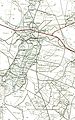
 Coimbatore circular railway.jpg 567 × 478; 41 KB
 Colchagua-1750 01.png 2,550 × 3,300; 3.97 MB
 Colchagua-1800.png 2,550 × 3,300; 4.01 MB
 Cold Lake Location Regression.png 1,152 × 648; 31 KB
 Colored Map of Andanian States.jpg 2,048 × 1,536; 75 KB
 Colusa County Geological Survey.jpg 3,648 × 3,066; 2.45 MB
 Commonwealth of Independent States.png 120 × 120; 17 KB
 Communauté de communes de l'outre forêt.png 461 × 517; 28 KB
 Communauté de communes pays rhénan.png 461 × 517; 28 KB
 CommuneMixteBibans.jpg 2,262 × 1,491; 202 KB
 Conde-map-Hollow-Tree-Nights-and-Days-1915.jpg 635 × 900; 282 KB
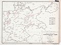 Confidential 1944 Map of location and population of German concentration camps.jpg 3,000 × 2,200; 1.27 MB
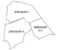 Conj.Jereissati.png 1,307 × 1,127; 140 KB