Commons:Graphic Lab/Map workshop
Contents
- 1 Age of Consent
- 2 MH370 PNG maps - Chinese requested
- 3 Location maps of Sri Lanka
- 4 can i get map of villege urali devachi taluka haveli district poona then bombay distrist maharashtra?
- 5 Map labels from Norwegian to English
- 6 Sri Lankan province and district location maps
- 7 Browser Market Map
- 8 Translate the image (Montrealmetromap.svg) into Malay language (code:ms)
- 9 Limassol District
- 10 Iranian Presidential Election Results
- 11 Visa policy of Bulgaria update
- 12 African colonies
- 13 SVG convert
- 14 Arabic version of this map
Age of Consent[edit]
-

Global age of consent
-

North America
- Article(s)
- Many
- Request
- Add details for Mexico to File:Age of Consent - Global.svg, as was done for the United States and Australia. --Delphi234 (talk) 03:17, 27 May 2015 (UTC)
- Graphist opinion(s)
I think this was actually done (by User:Gajmar on 11:44, 11 December 2016). I would mark this as resolved.--Lommes (talk) 21:25, 28 April 2017 (UTC)
MH370 PNG maps - Chinese requested[edit]
-

Flight path
-
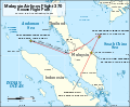
SVG
-

ATC and air routes
-
- Article(s)
- MH370
- Request
- Simplified Chinese translations of the following maps requested:
Key for File:MH370 flight path with English labels.png:
- Malaysia Airlines Flight 370 Known Flight Path - 马航370航班的已知路径
- Source: Joint Investigation Team - 来源:联合调查组
- Departs KLIA 12:41 MYT (16:41 UTC) - 于12:41大马标准时间(协调世界时16:41)在吉隆坡国际机场出发
- Last ACARS message 1:06 MYT (17:06 UTC) - 最后飞机通信寻址与报告系统信息 (ACARS)于1:06大马标准时间(协调世界时 17:06)发出
- Last secondary radar contact 01:22 MYT (17:22 UTC) - 最后与二次雷达接触的大马标准时间为 01:22 (协调世界时 17:22)
- 200nm (370km/230mi) - 200海里 (370公里/230英里)
- Last primary radar contact 02:22 MYT (18:22 UTC) - 最后与一次雷达接触的大马标准时间为 02:22 (协调世界时 18:22)
- Andaman Sea - 安达曼海
- Nicobar Islands (India) - 尼科巴群岛 (印度)
- Indian Ocean - 印度洋
- Indonesia - 印尼
- Banda Aceh - 亚齐
- Medan - 棉兰
- Malaysia - 马来西亚
- Ipoh - 怡保
- Kuala Terengganu - 瓜拉登嘉楼
- Penang - 槟城
- Kuala Lumpur - 吉隆坡
- Singapore - 新加坡
- Thailand - 泰国
- Hat Yai - 合艾
- Vietnam - 越南
- Can Tho - 芹苴
- Ho Chi Minh City - 胡志明市
- Cambodia - 柬埔寨
- Gulf of Thailand - 泰国湾
- 10oN - 北纬10度
- 5oN - 北纬5度
- 0o - 赤道0度
Key for File:MH370 ATC and air routes map.png
- Malaysia Airlines Flight 370 Air Traffic Control and Air Routes - 马航370航班空管和空中航线
- FIR Ho Chi Minh - 胡志明市飞航情报区
- FIR Singapore - 新加坡飞航情报区
- FIR Bangkok - 曼谷飞航情报区
- FIR Kuala Lumpur - 吉隆坡飞航情报区
- Gulf of Thailand - 泰国湾飞航情报区
- South China Sea - 南中国海
- Malaysia - 马来西亚
- Kuala Terengganu - 瓜拉登嘉楼
- Kota Bharu - 哥打巴鲁
- Thailand - 泰国
- Narathiwat - 那拉提瓦
- Vietnam - 越南
- 105oE - 东经105度
- 7oN - 北纬7度
- ATC for routes M765 & R208 through FIR Singapore provided by Kuala Lumpur ACC - 通过新加坡飞航情报区M765和R208的空管航线是由吉隆坡区域管制中心所提供
- Disappears from secondary radar (1:21 MYT) - 从二次雷达中消失 (大马标准时间 1:21)
- Flight path - secondary radar - 二次雷达所探测到的飞行路径
- Flight path - military radar - 军用雷达所探测到的飞行路径
- Planned Flight Path - 原定飞行路径
- Flight Information Region (FIR) - 飞航情报区
- FIR Boundaries (includes international border) - 飞航情报区边界(包括国际边界)
- Air route (selected named) - 特定空中航线
- Navigational waypoint (selected) - 特定导航点
- International border (also forms FIR boundary) - 国际边界(也形成飞航情报区边界)
- 1. Source: MH370 - Definition of Underwater Search Areas Australian Transport Safety Bureau, June 2014, pg. 3 - 来源:《MH370 - 水下搜索区域的界定》,第3页, 由澳洲交通安全局于2014年6月发布。
- 2. Based on the flight path taken by MAS Flight 370 in several flights shortly before 8 March 2014. - 根据2014年3月8日前夕的MH370数次航班的飞行路径。
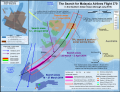
File:MH370 SIO search.png (Translation by User:Cerevisae):
   The Search for Malaysia Airlines Flight 370
   In the Southern Indian Ocean (through July 2015) - 搜寻马来西亚航空公司航班370
   在南印度洋(至2015年7日)
   104oE - 东经104度
   103o50' E - 东经103度50分
   45oS - 南纬45度 (and so on)
   Elevation (metres) - 海拔(米)
   7th BTO arc - Location (distance from satellite) of Flight 370 at the time of its last transmission (8:19 MYT / 00:19 UTC, 8 March 2014) - 第七突发时序偏移弧 - 370航班的位置(与卫星的距离)(break)在当时的最后一次发送的时间 (break)(大马标准时间 8:19/协调世界时 00:19,2014年3月8日)
   Above sea level - 海拔(米)
   Cocos Is. (Australia) - 科科斯群島 (澳洲)
   Detected by sonobuoy - 由声纳浮标所检测
   Location (area of uncertainty) of an event detected by hydrophone stations about at 1:30 UTC, 8 March 2014 - 于2014年3月8日协调世界时 1:30(break)通过水听器站点所检测到的地点(不确定区)的有关事件
   Search areas 3-11 April 2014 - 4月3日至11日的搜索区域
   Search areas 12-28 April 2014 - 4月12日至28日的搜索领域
   Broken Ridge - 布罗肯海岭
   Search areas 28 March - 3 April 2014 - 3月28日至4月3日的搜索领域
   TPL search & seafloor sonar survey (inset) - 拖行声波定位器搜索和海底声呐调查(插图)
   Search areas 18 - 27 March 2014 - 3月18日至27日的搜索区域
   Australia - 澳洲
   Amsterdam Is. (France) - 阿姆斯特丹岛 (法国)
   Saint Paul Is. (France) - 圣保罗岛(法国)
   Perth Canyon (IMOS) - 珀斯峡谷 (综合海洋观测系统)
   Perth - 珀斯
   RAAF Base Perce - 澳大利亚皇家空军的皮尔斯基地
   Fremantle Harbour - 弗里曼特尔海港
   Cape Leeuwin - 露纹角
   HA01 (CTBTO) - 条约编号:HA01(全面核禁试条约组织)
   Note: Surface search areas (18 March - 28 April 2014) were influenced by ocean drift from possible impact location over intervening time (since 8 March 2014) - 注:水面搜索区域(2014年3月18日至4月28日)。(break) 该搜索区域是由可能的坠毁的位置(break)和海洋漂移所影响(自2014年3月8日)。
   Path of ADV Ocean Shield with Towed Pinger Locator (4-14 April) - 海洋之盾号与拖行声波定位器的路径(4月4日至14日)
   Acoustic detections - 声音检测器
   Max. effective detection range (3 km) - 最大有效检测范围(3公里)
   Seafloor sonar survey (14 April-28 May) - 海底声纳调查(4月14日至5月28日)
   Sources: Royal Australian Navy & Phoenix International - 资料来源:澳洲皇家海军与凤凰国际
   Flight path / impact area calculations - 飞行路线/坠毁面积计算
   18 March 2014 - 2014年3月18日
   28 March 2014 - 2014年3月28日
   3 April 2014 - 2014年4月3日
   Highest probability - 最高概率
   Medium probability - 中等概率
   Lowest probability - 最低概率
   October 2014 - 2014年10月
   Facilities used: - 设备使用:
   Port - 港口
   Airfield - 机场
   Underwater search: - 水下搜索:
   Sonobuoy deployments - 声纳浮标部署
   Hydrophone stations - 水听器站点
   Satellite images of possible debris: - 卫星图像所显示的可能碎片:
   Thaichote (24 March 2014) - 泰国地球观测卫星(2014年3月24日)
   Gaofen-1 (18 March 2014) - 高分一号卫星 (2014年3月18日)
   Airbus (23 March 2014) - 空客防务卫星(2014年3月23日)
   Digital Globe (16 March 2014) - 數位全球公司卫星(2014年3月16日)
   Priority search area - 60,000 km2 (began October 2014, largely complete by May 2015) - 优先搜索区域 - 60,000平方公里(始于2014年10月,2015年5月大致上完成)
   Expanded search area - 120,000km2 (approx. boundary, announced April 2015, began May 2015) - 扩大搜索范围 - 120,000平方公里(预计边界,于2015年4月宣布,开始于2015年5月)
   Wide area search - 1,120,000 km2 (identified, but no plans to search as of 31 July 2015) - 大范围搜索 - 1,120,000平方公里 (已确定,但截至于2015年7月31日,还没有计划要开始搜索)
   Sources: Australia Maritime Safety Authority & Australian Transport Safety Bureau - 资料来源:澳洲海事安全局和澳洲交通安全局
   Map by Andrew Heneen (December 2014, updated 31 July 2015), Licenced: CC-BY-3.0 - 地图来自Andrew Heneen(创作于2014年12月,更新于2015年7月31日),拥有“创作共用授权 - 署名 - 相同方式共享”条款的许可。
WhisperToMe (talk) 22:13, 11 August 2015 (UTC)
Location maps of Sri Lanka[edit]
-

(1)
Main location map -

(2)
Main location map (relief) -

(3)
NASA topography map -

(4)
Custom-made to show Provinces. To be deleted.Google Earth borders are wrong. -
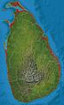
(5)
Custom-made to show Districts. To be deleted.Google Earth borders are wrong. Use this only for details on the northern borders. -

(6)
Scanned map from Survey Department to show accurate borders. To be deleted.
- Article(s)
- en:Template:Location map Sri Lanka
- en:Module:Location map/data/Sri Lanka Northern Province
- (more modules to be created)
- Request
- Replace the topography detail of the existing relief map (2nd file), with that of the more accurate and detailed NASA map (3rd file). (recolouring will be needed)
- Sharpen the provincial and district borders with those as shown on
files 4 and 5file 6. These two files are samples only, and are to be deleted. - Fix borders on the relief map (top area - 2nd file).
- Make provincial borders thicker than district borders.
- Remove the two rivers and reservoirs from the first two maps (see also), and
- If needed, you may visit this page to test the accuracy of the country's borders. The placemark's coordinates are very accurate (taken from Google Earth), and shows the extreme ends of the country. Thanks! Rehman 05:33, 25 March 2016 (UTC)
- Graphist opinion(s)
Sri Lanka adm location map.svg and Sri Lanka rel location map.svg are available now. NNW 21:20, 18 May 2016 (UTC)
- Thank you, NNW! Looks great! Just a few changes, would you be able to remove all the rivers and waterbodies from both new maps, and make the 2nd level (district) borders more lighter (lighter grey)? And instead of just trashing the river details which I just mentioned, would you be able to upload it to a completely new svg file using the topographic background, and including only rivers and 1st level/province borders, but no waterbodies. This will be very useful for the river articles which I am currently working on. Thank you so much for your help. Cheers, Rehman 01:30, 21 May 2016 (UTC)
- Deleting all lakes? Some rivers flow through lakes. Sri Lanka adm location map.svg and Sri Lanka rel location map.svg are showing only 1st level borders now, Sri Lanka adm-2 location map.svg and Sri Lanka rel-2 location map.svg 2nd level borders, too, with these borders with a thiner line. All these maps are part of a set of maps which all have to look the same. I can upload further files but they won't have file names related to location maps but you can use them as alternative maps for the template maps. NNW 16:58, 23 May 2016 (UTC)
@NNW: Sorry for the late reply. Please ignore my previous comment. Instead, would you be able to replace File:Sri Lanka location map.svg with File:Sri Lanka adm-2 location map.svg, but removing all the rivers while retaining the water bodies? This is because the current default map:
- does not have the waterbodies marked properly
- has no distinction between provinces and district borders
- and has less sharper borders when compared to the map you created.
Removal of rivers is because:
- the current map doesn't have rivers
- not all rivers are mapped
- having rivers will confuse viewers for borders, and looks too cluttered as well.
Similarly, the same applies to the relief maps (File:Sri Lanka relief location map.jpg and File:Sri Lanka rel location map.svg), but to add district borders as well. Please let me know if this is possible. Thank you, Rehman 14:00, 7 July 2016 (UTC)
can i get map of villege urali devachi taluka haveli district poona then bombay distrist maharashtra?[edit]
-
IMAGE1.EXT
Description of first image
-
IMAGE2.EXT
Description of second image (if needed)
-
IMAGE3.EXT
Description of third image (if needed; don't request too many at once, though)
Article(s): [[]]
- Request
- can i get map of villege urali devachi taluka haveli district poona then bombay distrist maharashtra?… --Vasantpatwardhan (talk) 12:59, 20 August 2016 (UTC)
- Graphist opinion(s)
Map labels from Norwegian to English[edit]
-

Map showing the Bronze Age collapse (conflicts and movements of people)
-

SVG replacement in English
Article(s): en:Late_Bronze_Age_collapse
- Request
- It would be nice to have the labels for this map translated to English. They seem pretty simple, but it may be a challenge to alter the existing map, so making a replacement might be better. --JesseW (talk) 16:17, 31 August 2016 (UTC)
- Graphist opinion(s)
JesseW are you able to provide the translations? Offnfopt(talk) 14:45, 7 November 2016 (UTC)
- Offnfopt, sadly, I am not -- I do not speak Norwegian. I just came across the map, and thought it worth mentioning it somewhere it would be more likely to get done. JesseW (talk) 04:56, 12 November 2016 (UTC)
Ok, try the above, Huldra (talk) 00:26, 28 December 2016 (UTC)
- Thanks! Offnfopt, it looks like we have translations now -- would you be able to make a English-language version of the map with them? JesseW (talk) 06:03, 29 December 2016 (UTC)
- @JesseW:, @Offnfopt:, @Huldra:, : I would perhaps do this, but not if someone is already working on this. Is this stale or still active?? --Lommes (talk) 22:41, 29 April 2017 (UTC)
- @Lommes: I have no idea, I don't do maps. But if anything is unclear about translation from Norwegian, please don't hesitate to ping me, Huldra (talk) 22:51, 29 April 2017 (UTC)
- @Lommes: Please do it, I'm not aware of anyone else working on it! JesseW (talk) 23:00, 30 April 2017 (UTC)
-
- @JesseW:, @Offnfopt:, @Huldra: Can you check if this is okay? Thank you.--Lommes (talk) 15:45, 2 May 2017 (UTC)
- @Lommes:, that look good, except you forgot the names of https://en.wikipedia.org/wiki/Ugarit and https://en.wikipedia.org/wiki/Alalakh? Otherwise, fine! Huldra (talk) 20:26, 2 May 2017 (UTC)
- Oh, and is it spelled Lybians? Isn't it Libyans? Huldra (talk) 20:30, 2 May 2017 (UTC)
- Oh, and those arrows, showing the progress of the sea people are a bit off? Huldra (talk) 20:35, 2 May 2017 (UTC)
-
- @Huldra: Please check again. Thank you.--Lommes (talk) 21:14, 2 May 2017 (UTC)
- @Lommes: That looks excellent to me! Huldra (talk) 21:23, 2 May 2017 (UTC)
- @Huldra: Will you do the replacement in the used articles? If this is finished, can you please mark this section as {{section resolved}}...? Thank you.--Lommes (talk) 21:33, 2 May 2017 (UTC)
- @Lommes: That looks excellent to me! Huldra (talk) 21:23, 2 May 2017 (UTC)
- @Huldra: Please check again. Thank you.--Lommes (talk) 21:14, 2 May 2017 (UTC)
-
- @JesseW:, @Offnfopt:, @Huldra: Can you check if this is okay? Thank you.--Lommes (talk) 15:45, 2 May 2017 (UTC)
-
- @JesseW:, @Offnfopt:, @Huldra:, : I would perhaps do this, but not if someone is already working on this. Is this stale or still active?? --Lommes (talk) 22:41, 29 April 2017 (UTC)
Sri Lankan province and district location maps[edit]
Article(s): Numerous Sri Lankan articles
- Request
- Currently only two of the nine provinces and one of the twenty five districts have location maps. It would be great if the remainder also had location maps. I appreciate this is a big ask but anything would be appreciated.--Obi2canibe (talk) 12:24, 8 September 2016 (UTC)
- Graphist opinion(s)
- Non-graphist comment: The same outcome is requested in part of the #Location maps of Sri Lanka section above. Rehman 13:10, 8 September 2016 (UTC)
-
- That request relates to island wide maps - my request is for province/district specific maps.--Obi2canibe (talk) 13:14, 8 September 2016 (UTC)
- Obi2canibe and Rehman This may not answer all your map needs but there is now a way of using and annotating Open Street Maps, which can provide a different way of showing map data without each map having to be made specially. It won't integrate into info-boxes and uses a template at en:template:OSM Location map which might need porting across to non-en wiki's. But as an example, I have added a map at en:Sabaragamuwa Province to show an example of what is possible. It could also be used to add red locator dots etc to show specific features. (Unfortunately the Open Street Map version available does not currently show Sri Lanka district boundaries}. RobinLeicester (talk) 21:31, 2 January 2017 (UTC)
- Thanks RobinLeicester, that's great news! Rehman 14:52, 3 January 2017 (UTC)
Browser Market Map[edit]
Article(s): en:Usage share of web browsers
- Request
- May you please do an updated map from Statcounter data? The July 2016 file is corrupt.--Kopiersperre (talk) 15:19, 9 November 2016 (UTC)
- Graphist opinion(s)
Translate the image (Montrealmetromap.svg) into Malay language (code:ms)[edit]
-

Map of the Montreal metro system
Article(s): Metro Montreal
- Request
- Hello. Can someone help me by translating the image above into Malay language (bahasa Melayu)? Thank you.
-
- Légende/legend → Petunjuk
- Station de métro/Metro station → Stesen metro
- Station intermodale/Intermodale station → Stesen antara mod
- Ligne de trains de banlieue/Commuter train line → Laluan kereta api komuter
- Ascenseur/elevator → Lif
-
- Direction Saint-Jérôme → Ke arah Saint-Jérôme
- Direction Mascouche → Ke arah Mascouche
- Direction Deux-Montagnes → Ke arah Deux-Montagnes
- Direction Vaudreuil–Hudson → Ke arah Vaudreuil–Hudson
- Direction Mont-Saint-Hilaire → Ke arah Mont-Saint-Hilaire
- Direction Candiac → Ke arah Candiac
--26 Ramadan (talk) 10:00, 15 December 2016 (UTC)
- Graphist opinion(s)
![]() Request taken by Houdinipeter (talk) 16:05, 16 February 2017 (UTC) This will take a bit of work because the words are rendered as paths for each letter (in layman's terms: shapes) instead of together as easily editable text.
Request taken by Houdinipeter (talk) 16:05, 16 February 2017 (UTC) This will take a bit of work because the words are rendered as paths for each letter (in layman's terms: shapes) instead of together as easily editable text.
 Done I did this, but upon uploading it seems that there was already a Malay metro map. In the edit I just updated the existing one to be more efficient.
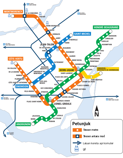
Limassol District[edit]
-

Original PNG
-

SVG replacement
Hello. I have uploaded File:Limassol District.png. Is not good. The resolution is not good, the small maps is not good, the file is not svg. Can anyone create the same map without my mistakes? Xaris333 (talk) 10:53, 28 January 2017 (UTC)
Iranian Presidential Election Results[edit]
-

Map of Iranian presendtions election by province.
-

Map of Iranian presendtions election by province.
Article(s): ar:انتخابات إيران الرئاسية 2017
- Request
Remove the English text form the image, so it can be used in all wiki languages. If this is not available, for a reason or another, Arabic text will be great.--Aladdin (talk) 21:54, 20 May 2017 (UTC)
- Graphist opinion(s)
-
- I will upload a version without any texts after official results per province come out. Ali 18:04, 21 May 2017 (UTC)
Visa policy of Bulgaria update[edit]
-

Visa policy of Bulgaria
Article(s): en:voy:Bulgaria
- Request
- Could someone update this map to show the countries that have visa free travel to Bulgaria, there's a list of these countries at English Wikivoyage, here. Thank you! --Seagull123 (talk) 16:38, 26 May 2017 (UTC)
- Graphist opinion(s)
@Seagull123: I can do it but it would be much easier for me if you listed countries to remove and add, thanks. --Goran tek-en (talk) 16:54, 12 July 2017 (UTC)
- @Goran tek-en: Could you add Australia, Antigua and Barbuda, Canada and the US please. Thank you so much! Seagull123 (talk) 22:00, 13 July 2017 (UTC)
![]() Request taken by Goran tek-en (talk) 18:09, 14 July 2017 (UTC)
Request taken by Goran tek-en (talk) 18:09, 14 July 2017 (UTC)![]() Done
Done
-
- @Seagull123: Now there is a new version, you should check it for there are island with USA etc that is difficult to know. Also that file needs a category, could you please fix that.
- If you are happy with the map please put the code
{{section resolved|1=~~~~}}here so the request can be archived, thanks. --Goran tek-en (talk) 18:09, 14 July 2017 (UTC)- Yes, thank you very much for that work! It's very good
 Seagull123 (talk) 20:15, 14 July 2017 (UTC)
- Yes, thank you very much for that work! It's very good
- @Seagull123: Now there is a new version, you should check it for there are island with USA etc that is difficult to know. Also that file needs a category, could you please fix that.
African colonies[edit]
-

example for the en:Belgian Congo
-

Example for the en:French Algeria
-
.svg/117px-Mapa_del_Magreb_(1956).svg.png)
Example for the en:French protectorate in Morocco
Article(s): es:Congo Belga, es:Protectorado francés de Marruecos, es:Colonización francesa de Argelia and the respective article in each language.
- Request
- Hi, do you can do a map of this three colonial territories, in the case of the Belgian Congo it exist one but it has a very lower quality.--Fr2002 (talk) 21:52, 10 June 2017 (UTC)
- Graphist opinion(s)
SVG convert[edit]
-

JPG map
Article(s): I haven´t created yet.
- Request
- I´m developing a article in my sandbox to turn a good article and I'd like a SVG version by this map. --Mr. Fulano (talk) 01:00, 13 June 2017 (UTC)
- Graphist opinion(s)
@Mr. Fulano: I could help you with that but as I don't really understand the current map I will need your help on this.
- There is so much information in that map, do you need all of it?
- Does the overall areas of the two maps show the ones you need or can we zoom in closer?
- On the left map, is it important to show the mountains, is it not more important to show the different locations better?
- On the right map, do you need the coloring for heights?
- To my understanding I can't anyway copy the map right of, read here. Did you check if this was free to take? --Goran tek-en (talk) 16:47, 12 July 2017 (UTC)
-
- @Goran tek-en: The most important is the species localization, so you can close the right map. If you can, put a localization map in Peru. I thinking the height is important, but if you can't do this, you can remove. And the image is in CC, how you can see here, in authors section. I've been created the article, is here. Mr. Fulano (talk) 17:12, 12 July 2017 (UTC)
![]() Request taken by Goran tek-en (talk) 18:33, 12 July 2017 (UTC)
Request taken by Goran tek-en (talk) 18:33, 12 July 2017 (UTC)
-
-
- @Mr. Fulano: I want you to look at this draft. It's only for the base map, I want to know if it's OK for you?
- Are the red and white circles the localization's, if so do you want numbers on the different ones?
- What do you mean by "If you can, put a localization map in Peru", do you mean the borders of Peru? --Goran tek-en (talk) 18:41, 13 July 2017 (UTC)
- @Goran tek-en: In fact, the localization is the yellow circle. The red and white circles is the other species localization and isn't the most important. And when I said that, I wanted talk to do anything like this, showing where the map close, on the bottom. Mr. Fulano (talk) 18:59, 13 July 2017 (UTC)
- @Mr. Fulano: I'm sorry but I'm totally lost now...
- You started of with wanting a svg version of the map you linked to. Then you wrote the right side map didn't need to be included, now you say the localization is the yellow circle which to me is in the right side map. Then you link to a totally other map and say you want something like that.
- You have to realize that I have no knowledge of this subject and I can't read your thought's. You have to tell me exactly what you want otherwise I can't help you and both you and I wast time on something which turn out to be wrong.
- So we have to start from the beginning, you have to tell me what area the map should cover to start with. --Goran tek-en (talk) 19:40, 13 July 2017 (UTC)
- @Goran tek-en: I'm sorry, I did not explain well. What I want is a map that shows the location of the Rhinella lilyrodriguezae (yellow dot) that is represented in the smaller map. So I would like this map to be focused, but showing below, like the other map I showed you, the area of the map that has been enlarged. Mr. Fulano (talk) 20:18, 13 July 2017 (UTC)
- @Mr. Fulano: I'm sorry but I'm totally lost now...
- Are the red and white circles the localization's, if so do you want numbers on the different ones?
- @Mr. Fulano: I want you to look at this draft. It's only for the base map, I want to know if it's OK for you?
-
@Mr. Fulano: I want you to look at this image. Is it OK to have this a base map for the overall location or must that also be a topographic map?
Do you know if the natur of the location is in mountains or is it green land? It's just the map you linked to start with that shows it as green, every other map I have checked has much more mountains there. --Goran tek-en (talk) 17:50, 14 July 2017 (UTC)
- @Goran tek-en: For me is great. And answering the other ask, I don't know, but I think is a forest and a mountain. Mr. Fulano (talk) 20:58, 15 July 2017 (UTC)
- @Mr. Fulano: Now there is a draft for you to look at. I don't know how much you know about the difference between a bitmap image (e.g. digital photo) and a svg image. In a bitmap every pixel has information about color, position and so on. So they are very good to show e.g. a topographic map. A svg is more like a mathematical image, you don't have information on every pixel in the same way. Svg is normally better for e.g. solid colors, lines and so on. When a topographic map is created as a svg it becomes very big in Mb because there are so many different nodes it has to hold information on and still the outcome is not as smooth as a bitmap version.
- With that said here is the draft for you to look at and give me feedback on, anything goes. Do you want a legend with explanation, scale, north etc.?
- @Goran tek-en: I'd want a SVG map because the actual map isn't so visible and I'm so busy to create it . And for me, the draft is great, and isn´t necessary put the legend, because I can descript it in the infobox article.
- @Mr. Fulano: If you are happy with the draft and don't want anything changed I will need the following;
- Name of the file: Distribution map of Rhinella lilyrodriguezae.jpg
- Description: The green diamond corresponding the Rhinella lilyrodriguezae distribuition and the red stripe is the limits of Cordillera Azul National Park.
- Category/ies at commons: Rhinella lilyrodriguezae, Rhinella distribution maps and SVG maps of Peru.
- to be able to upload it at commons, thanks. --Goran tek-en (talk) 21:52, 18 July 2017 (UTC)
- @Goran tek-en: See above. Mr. Fulano (talk) 22:51, 18 July 2017 (UTC)
- @Mr. Fulano: If you are happy with the draft and don't want anything changed I will need the following;
- @Goran tek-en: I'd want a SVG map because the actual map isn't so visible and I'm so busy to create it . And for me, the draft is great, and isn´t necessary put the legend, because I can descript it in the infobox article.
- @Mr. Fulano: Now there is a draft for you to look at. I don't know how much you know about the difference between a bitmap image (e.g. digital photo) and a svg image. In a bitmap every pixel has information about color, position and so on. So they are very good to show e.g. a topographic map. A svg is more like a mathematical image, you don't have information on every pixel in the same way. Svg is normally better for e.g. solid colors, lines and so on. When a topographic map is created as a svg it becomes very big in Mb because there are so many different nodes it has to hold information on and still the outcome is not as smooth as a bitmap version.
@Mr. Fulano: Now you can find it here Distribution map of Rhinella lilyrodriguezae.svg. --Goran tek-en (talk) 19:40, 19 July 2017 (UTC)
![]() Done
Done
- @Goran tek-en: Thank you for this great work! Mr. Fulano (talk) 19:58, 19 July 2017 (UTC)
Arabic version of this map[edit]
-
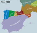
Chronological map showing linguistic evolution in southwest Europe
Article(s): تأثير اللغة العربية في اللغة الإسبانية
- Request
- Can you please create an Arabic Version of this animated map? Translations are as follows:
- Year 1000 = سنة 1000م
- Year 1050 = سنة 1050م
- Year 1100 = سنة 1100م
- Year 1150 = سنة 1150م
- Year 1200 = سنة 1200م
- Year 1250 = سنة 1250م
- Year 1300 = سنة 1300م
- Year 1400 = سنة 1400م
- Year 1500 = سنة 1500م
- Year 1600 = سنة 1600م
- Year 1700 = سنة 1700م
- Year 1800 = سنة 1800م
- Year 1900 = سنة 1900م
- Year 2000 = سنة 2000م
- Langues d'oïl = لٌغات أوييليَّة
- Franco-Provençal = الإفرنجيَّة الپروڤنساليَّة
- Occitan = الأقطانيَّة
- Catalan = القطلونيَّة
- Aragonese = الأراغونيَّة
- Basque = البشكنسيَّة (الباسكيَّة)
- Castilian = القشتاليَّة
- Leonese = الليونيَّة
- Portugese / Galician = الپُرتُغاليَّة \ الجُليقيَّة
- Arabic & Mozarabic = العربيَّة والمُستعربيَّة
- French = الفرنسيَّة
Thanks in Advance. Best--باسم (talk) 21:32, 14 June 2017 (UTC)
- Graphist opinion(s)
@باسم: There is quite some work in this but I will do it. ![]() Request taken by Goran tek-en (talk) 18:16, 23 June 2017 (UTC)
Request taken by Goran tek-en (talk) 18:16, 23 June 2017 (UTC)
- @Goran tek-en: Thank you Please inform me if you needed anything--باسم (talk) 18:20, 23 June 2017 (UTC)
- @باسم: Does this translation need to be that long, it looks like two versions. It will be very small. Basque = البشكنسيَّة (الباسكيَّة) --Goran tek-en (talk) 18:39, 23 June 2017 (UTC)
- @Goran tek-en: no no need if its gonna be hard, these are two names for the same language but the 1st is the old naming used in Muslim spain, you can use الباسكيَّة since its the modern version--باسم (talk) 18:57, 23 June 2017 (UTC)
- @باسم: It will take several hours, do you want it, yes or no? --Goran tek-en (talk) 19:13, 23 June 2017 (UTC)
- @Goran tek-en: yes please, take your time--باسم (talk) 19:20, 23 June 2017 (UTC)
- @باسم: Can you make a version of this translation Franco-Provençal = الإفرنجيَّة الپروڤنساليَّة which is on two lines, thanks. --Goran tek-en (talk) 13:33, 25 June 2017 (UTC)
- @Goran tek-en: yes of course, its:
- الإفرنجيَّة
- الپروڤنساليَّة
- Best--باسم (talk) 13:59, 25 June 2017 (UTC)
- @باسم: Can you make a version of this translation Franco-Provençal = الإفرنجيَّة الپروڤنساليَّة which is on two lines, thanks. --Goran tek-en (talk) 13:33, 25 June 2017 (UTC)
- @Goran tek-en: yes please, take your time--باسم (talk) 19:20, 23 June 2017 (UTC)
- @باسم: It will take several hours, do you want it, yes or no? --Goran tek-en (talk) 19:13, 23 June 2017 (UTC)
- @Goran tek-en: no no need if its gonna be hard, these are two names for the same language but the 1st is the old naming used in Muslim spain, you can use الباسكيَّة since its the modern version--باسم (talk) 18:57, 23 June 2017 (UTC)
- @باسم: Does this translation need to be that long, it looks like two versions. It will be very small. Basque = البشكنسيَّة (الباسكيَّة) --Goran tek-en (talk) 18:39, 23 June 2017 (UTC)
@باسم: Now there is draft for you to look at, give me feedback, thanks. --Goran tek-en (talk) 18:24, 10 July 2017 (UTC)
- @Goran tek-en: its perfect you can uploade it whenever you can. Many thanks--باسم (talk) 19:32, 10 July 2017 (UTC)
- @باسم: Now you can find it here. Chronological map showing linguistic evolution in southwest Europe from A.D. 1000-2000.
- @باسم: Now you can find it here. Chronological map showing linguistic evolution in southwest Europe from A.D. 1000-2000.
![]() Done
Done
@باسم: Why didn't you want the description to be in any other language than Arabic? --Goran tek-en (talk) 21:30, 11 July 2017 (UTC)
- @Goran tek-en: Since its in Arabic and Most likely will be only used on ar.wiki and other Arabic sister projects maybe, and because the original is already there. I don't mind adding any other languages--باسم (talk) 21:56, 11 July 2017 (UTC)